Trade Winds
Trade winds were introduced in Chapter 1 (Global weather patterns) as the equatorward blowing part of the Hadley cell. Because many cruising boats spend a lot of time in the trade wind region, some more detailed information is given in this chapter.
Typical trade wind characteristics
The strength of the trade winds - like all the winds in the world - is predominantly determined by pressure gradient. Because the pressure of the equatorial trough, or ITCZ, is relatively stable at around 1008-1012 hPa, the strength of the trade winds is mostly determined by the strength and location of the subtropical high pressure. The stronger the high pressure is and the closer it is to the equator the stronger the pressure gradient and the trade winds are.
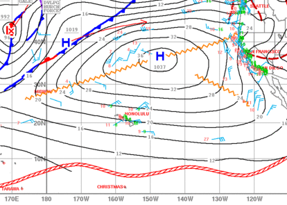
Figure 1 shows a subtropical high pressure of 1037 mb centered at 37°N, 147°W. That creates a large area of easterly trades of 15-30 knots between 30°N and ITCZ.

Figure 1. North Pacific surface pressure analysis shows a high pressure at 37°N, 147°W. The trade wind belt extends from about 30°N to ITCZ (red line between 0 and 10°N). (Image courtesy of NOAA.)
Trades are typically the most common and steady during the summer months. For example in Hawaii, that is in the middle of the North Pacific trade wind belt, the trades occur about 90% of the time during the summer months and about 50% of the time in the winter leading to total of 70% time of the year. During the winter, the mid-latitude low pressures are typically stronger and they take more southerly (northerly) route in the northern (southern) hemisphere breaking the subtropical high pressure pattern. The cold fronts from these low pressures can extend as far down as 15-20 degrees latitude. During the summer, the subtropical high pressure is quite steady and well-established, so the trade wind speed is also steady. Typical speeds range between 12 and 18 knots. During the winter, the wind speed varies more. For example, if a mid-latitude storm has "broken" the high pressure, winds can be quite light as the high pressure re-builds. On the other hand, in certain environmental conditions the high pressure can build up and become very strong. (In fact, hurricane force (> 64 kt) trade winds were recorded in Waikoloa, Hawaii in December 1978). Therefore the wind speed varies more during the winter - typically between 5 and 25 knots. However, the mean wind speed for both summer and winter stays relatively similar with annual average speed of about 14 knots.
Persistent trade winds generate seas that can be sometimes a little bit choppy. The average wave height is typically about 2 meters with a peak period of 9 seconds.
It should be noted that the direction of the trades can vary quite a lot depending on the location and shape of the subtropical high pressure. In Figure 1, the winds are northerly near the California coast whereas over Hawaii the trades have typical east or northeast direction. Approaching midlatitude low pressure systems and their cold fronts can reshape the high significantly, often making it more elongated in the north-south rather than east-west direction.

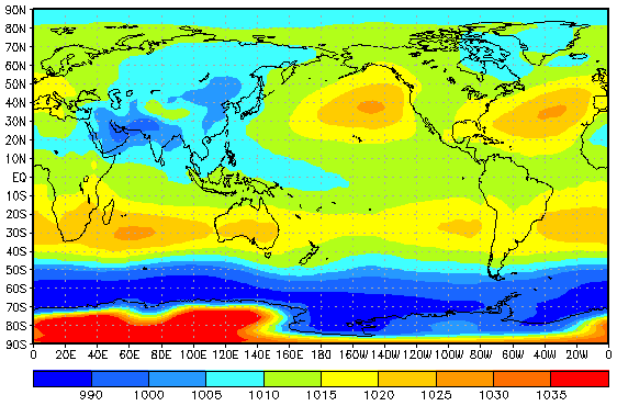
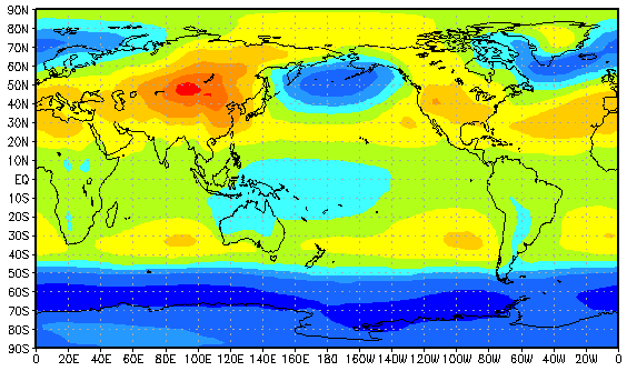
Figure 2. Monthly mean sea-level pressure for January (upper) and July (lower). (Image courtesy of NOAA.)
Figure 2 shows the mean sea-level pressure for January and July. Some noticeable features can be seen for each ocean basin: The dominating weather feature over the North Atlantic Ocean is the North Atlantic Anticyclone, or the Azores High (sometimes also known as Bermuda high). The southern flank of this large high pressure system forms the North Atlantic trade wind belt that transports sailors from the Canary Islands to Caribbean. On the north side of the high, westward moving lows dominate the weather (especially during the winter) and form a belt of westerlies in the midlatitudes. During the winter months, the Azores High shifts slightly southward. Also the north Atlantic low pressure systems typically take more southerly route and may reshape or even completely break down the Azores high, when the westerlies can extend down to 20°N or even 15°N. Fortunately these lows typically move quite fast and the high pressure builds up again in a few days.
Over the North Pacific, the high pressure shifts southeast, closer to the California coast, during the winter from its summer position north of Hawaii. The Aleutian low dominates the high latitudes. Similar to North Atlantic, the low pressures can break the high pressure and their cold fronts can extend far south to the trade wind belt.
The seasonal changes in the southern hemisphere are less dramatic than in the northern hemisphere. Over the South Atlantic, South Pacific, and South Indian Ocean the high pressures shift slightly to the north during the winter from their summer positions.
The winds over the North Indian Ocean are dominated by the monsoon. During the winter, there is a large high pressure over the asian continent and the large-scale flow over the area is from the northeast. During the summer monsoon, a large low pressure forms over the Asian continent and the wind direction is reversed with the dominant wind direction being from the southwest.

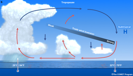
Figure 2. Trade wind inversion. Near the subtropical high pressure center (right) the trade wind inversion is strong and the clouds are shallow. Closer to the equator (left) the inversion weakens and clouds can grow tall. (Image courtesy of UCAR/COMET.)
Typical weather characteristics
Typical weather in the trade wind belt is partly sunny with some cumulus or stratocumulus clouds and a chance of showers. The clouds in the trade wind region do not usually grow very tall because of a layer of warmer air called trade wind inversion. Descending air in the subtropical high pressure together with upward surface fluxes create a layer of warm air at about 500-3000 m altitude. The air is stable at the inversion layer, so the clouds cannot grow taller than the inversion bottom. For example, if one sails from Canary Islands to Caribbean or from California to Hawaii, the trade wind inversion gets higher and weaker along the way. The bottom of the inversion rises from about 500-1000 m altitude to about 1500-3000 m along those routes. In practice that means taller clouds and more showers as one gets closer to the equator.
Although the weather is usually fair in the trade wind region, sometimes a synoptic-scale disturbance can weaken or break the inversion and thunderstorms can develop. These disturbances include upper-tropospheric lows, cold fronts, subtropical lows (Kona lows), and tropical cyclones. The last three can be seen and forecast from the surface charts. The upper-tropospheric lows, however, can be only seen from upper level charts (e.g. 500 mb). These disturbances can produce strong thunderstorms and squall lines locally, although normal trade wind pattern can be observed elsewhere at the surface. Some of these topics will be discussed in the upcoming chapters.


