Thunderstorms and lightning
Lightning is one of the nature's most impressive phenomena that can cause serious damage to boats and other structures and be fatal to humans. Thunderstorms are also often associated with very strong and gusty winds in addition to heavy rain or hail. This chapter gives some information about thunderstorms and discusses their geographical distribution over the oceans.
Evolution and electrification of thunderstorms
The development of a thunderstorm begins when warm, moist air rises upwards and the water vapor the air contains condenses and forms a cumulus cloud. If there is enough moisture and instability, the cloud grows taller and reaches a towering cumulus stage (Figure 1a). At this stage, the cloud is often so tall that it penetrates through the altitude level where temperature is 0°C (called 0-isotherm) and ice starts to form in the cloud. The 0-isotherm is typically at about 3-4 km altitude during the summer in the mid-latitudes and about 5 km altitude in the tropics.
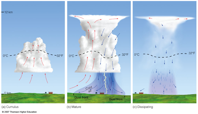
Figure 1. Three different stages of thunderstorm development. (Image courtesy of Thomson Higher Education.)
Figure 1b shows the mature stage of a thunderstorm where updrafts and downdrafts carry different sizes of ice particles vertically. When the particles collide, positive charge is transferred to small ice crystals and negative charge to larger graupel (soft hail). Effective charge separation also requires supercooled water (liquid water with temperature below freezing), so that the conductivity of the riming ice particles is sufficient. The lighter ice crystals are lifted to the upper part of the cloud forming an area of positive charge, whereas the heavier graupel stays in the middle and lower part of the cloud (negative charge). The resulting charge distribution has consequently created a vertical electric field in the cloud.
Lightning strikes
If the strength of the electric field exceeds the breakdown threshold (about 1-3 million V/m), a lightning stroke begins inside the cloud. First, a discharge of electrons rush towards the cloud base in a series of steps called stepped leader (Figure 2a,b,c). As the stepped leader approaches the ground, a more luminous return stroke surges upward from the ground to the cloud following the path of the stepped leader (Figure 2d,e). Often there is a subsequent dart leader descending from the cloud to ground using the same ionized channel and another return stroke. This process can repeat several times. Sometimes you can see a cloud-to-ground flash flickering - those are the subsequent return strokes. It is sometimes even possible to count the number of strokes with your bare eye. The number of return strokes within a flash varies between 1 and 40, with an average number of 3-4. Some slow-motion animations of flashes are shown in Figure 3 that illustrate the descending multi-branch stepped leader and the bright return stroke.
The strength of a lightning stroke is measured in kiloamperes (electric current) and commonly referred to as amplitude. The amplitude of the first cloud-to-ground return stroke varies between 5 and 300 kA with a median value of 30 kA. The amplitudes of flashes occurring inside the clouds (that never reach the ground) are smaller - typically less than 15 kA.

Figure 2. Downward propagating stepped leader followed by a return stroke. The illustrated flash carries negative charge to the ground and is called negative cloud-to-ground flash. (Images courtesy of NOAA.)
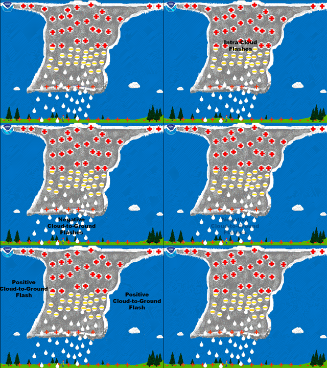
Figure 4. Typical charge structure of a thunderstorm and three different types of flashes: positive and negative cloud-to-ground flash and intra-cloud flash. (Image courtesy of NOAA.)
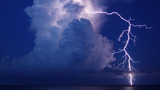
Figure 5. Lightning emanates from the upper part of the cloud first horizontally, then turns vertical and strikes the sea completely outside the cloud.(Image credit National Geographic/Kara Swanson.)
Different types of flashes
Figure 4 shows a typical charge structure of a mature thunderstorm. The upper part of the cloud has a positive charge, middle part of the cloud has a strong negative charge, and the lowest part has a weak positive charge. Lightning flashes that transfer negative charge to the ground are called negative cloud-to-ground flashes. Similarly, flashes that transfer positive charge to the ground are called positive cloud-to-ground flashes. On average, about 90% of flashes are negative. However, that number varies vastly between the storms.
The majority (about 75%) of all the lightning strokes in the world occur inside or between the clouds and never reach the ocean or land surface. Those are called generally intra-cloud flashes. The ratio of the number of intra-cloud (IC) flashes to the number of cloud-to-ground (CG) flashes is called the IC:CG ratio and it varies according to the storm type, stage, and also latitude, to some extent. A rough rule of thumb is that in the tropics the IC:CG ratio is between 5:1 and 10:1 and in the mid- and high latitudes the ratio is between 2:1 and 5:1. In other words, in the tropics, there can be 10 intra-cloud flashes for one cloud-to-ground flash.
Squall lines
The lifetime of a single-cell thunderstorm from cumulus stage to dissipating stage (shown in Figure 1) is typically 30-60 minutes. However, well-organized thunderstorms, such as squall lines, can last for several hours.
Squall lines are observed both in the mid-latitudes and over the tropical oceans. Mid-latitude squall lines are often associated with cold fronts and thus move eastward. In contrast, tropical squall lines move westward with the trades. A well-known spot for tropical squall lines is the west coast of Africa. The squall lines often form inland and then propagate over the Atlantic, sometimes very long distances. Some of these disturbances may also develop into tropical cyclones.
Squall lines can be hundreds of kilometers long in the meridional direction. A squall line consists of a convective part and a stratiform part. The convective part is at the leading edge of the storm and is usually relatively narrow. It is characterized by strong updrafts, lightning, and heavy rain. Downdrafts occur when falling hydrometeors (rain, ice) drag down cold air that is further cooled by evaporation. When the downdrafts hit the ocean surface, they spread out horizontally and create a boundary of very strong and gusty winds that is often called a gust front. The gust front leads the squall line and can be often felt well before the convective part arrives.
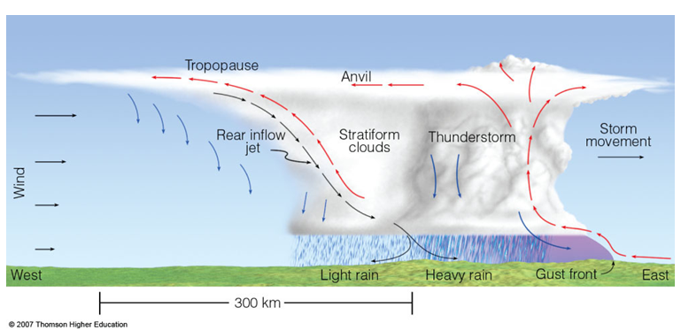
Figure 6. Eastward moving squall line. At the surface, the gust front arrives first followed by the convective part of the storm with heavy rain and lightning. That is followed by the stratiform part with a large area of light to moderate rain. (Image courtesy of Thomson Higher Education.)
The stratiform part trails the convective part and is usually much larger, often a couple of hundred kilometers wide. It is characterized by light to moderate rainfall and sometimes lightning. Winds are typically weaker than the gusts associated with the convective part.
Thunderstorm occurrence over the world's oceans
Thunderstorms occur only if the conditions are favorable, i.e. the atmosphere is unstable and there is enough moisture available. Thunderstorms tend to be more severe over the land and occur in the afternoons, partly because of the daytime heating of the land. In contrast, over the oceans the thunderstorm activity often peaks at night.
Thunderstorms require warm and moist air, so the high latitudes - both the oceans and land areas - see fewer thunderstorm per year. However, even in the tropics and subtropics, there are significant variations in thunderstorm occurrence zonally.
Most of the lightning in the world occur over the land. In fact, it is estimated that nearly 90% of all the lightning strokes hit the land, although land covers only 30% of the earth's total surface area. However, some parts of the oceans are still relatively lightning-active, as can be seen from Figure 7. The Intertropical Convergence Zone (ITCZ) or doldrums has naturally thunderstorms year round. Specifically the eastern and central parts of the Atlantic and Pacific Oceans near the ITCZ experience lots of lightning. Also the ocean areas east of the continents between about 30 and 50 latitude have lots of thunderstorms that have been often propagated from the continents and kept active over the relatively warm sea surface.
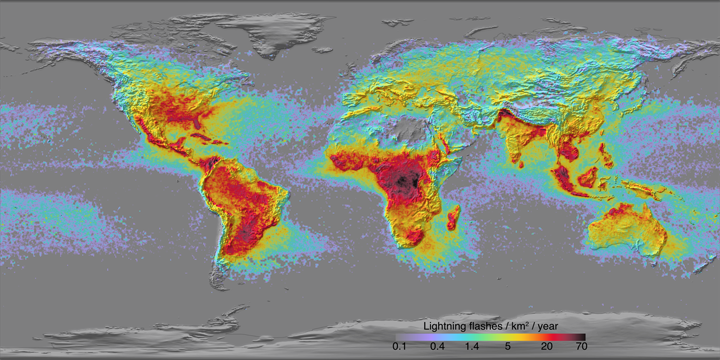
Figure 7. Average number of lightning flashes per year (per square km). Data are based on satellite-borne optical lightning detectors LIS and OTD. (Image courtesy of NASA.)
Minima in the number of lightning can be clearly seen over the California coast, east coast of South America, and the southeast parts of the Atlantic and Indian Oceans. The weather over those areas is dominated by the subtropical high pressure and sinking motion that usually prevents thunderstorms from occurring. Moreover, the cold ocean currents in the eastern ocean basins coming from high latitudes keep the environment unfavorable for thunderstorms.
In the trade wind belt and under typical trade wind conditions thunderstorms do not usually occur because of the trade wind inversion; the atmosphere is stable and dry near the inversion layer and any deep convection is suppressed. However, there are four types of conditions or weather disturbances when thunderstorms can occur in the trade wind region: (1) Tropical cyclones can be associated with lightning and they usually occur in the trade wind region during the summer or warm season. However, some basins see tropical cyclones year round (see Chapter 3). (2) Subtropical low pressures (Kona lows) are slow-moving storms that occur during the winter and often trigger some lightning. (3) Tropical Upper-Tropospheric Trough (TUTT) is a semipermanent trough in the upper levels of the troposphere. Typically it can be seen in the 200 hPa charts (or about 12 km altitude). Occasionally upper cold lows break off from TUTT and they can induce thunderstorms. (4) Cold fronts can penetrate deep into the trade wind belt during the winter when the mid-latitude low pressures are strong and take more southerly path.
Although the lightning counts in Figure 7 look low over many parts of the oceans (grey areas), it should be noted that they are not lightning free, they just have low lightning counts averaged over the years. Thunderstorms can still occur nearly anywhere in the world - even Cape Horn and coastal Alaska see some thunderstorms every year.
Lightning videos
Lightning strikes so fast that the only way to see the details of the lightning structure is to use high-speed cameras that record thousands of frames per second. Those videos reveal how the stepped leaders propagate towards the ground and the return stroke hits upward, often followed by subsequent return strokes in the same channel. Below are some links to video clips - enjoy!
Lightning strikes to boats
This article addressed thunderstorms and lightning from meteorological perspective and gave some advise when and where lightning may occur. If lightning actually strikes a boat, the consequences may be disastrous. The articles below talk about lightning damage to boats and how to minimize it.

